Tuesday 11 August 2015

LAST THINGS

THINGVELLIR NATIONAL PARK
GULLFOSS
STROKKUR GUSHES


MUD POT AT SELTUN
BLUE LAGOON

MY B&B IN KEFLAVIK
FISHING BOATS BEING MAINTAINED AT KEFLAVIK
COASTGUARD VESSEL NEAR KEFLAVIK
AMAZING WHALE-SHAPED ISLAND NEAR KEVLAVIK
HOLMSBERGSVITI LIGHTHOUSE
It's Saturday and I have all day to drive to Reykjavik. If I drove directly I would be there in about 3 hours, so I decided to take an indirect route.

A popular tourist route that comprises a large loop from Reykjavik to central Iceland and back, involving about 190 miles of driving, is called the Golden Circle. It includes stops at Thingvellir National Park, the waterfall Gullfoss (meaning Golden Falls) and the geysers Geysir and Strokkur at the geothermally active area Haikadalur.

I must admit to being a bit sniffy about doing this rather 'touristy' thing, which is why I left it until last and 'only if I had time'. However, my arrival at Thingvellir soon persuaded me that my attitude had been misplaced.

The National Park lies in a rift valley that marks the crest of the Mid-Atlantic Ridge. It is at the northern end of Thingvallavatn, the largest natural lake in Iceland.

The historical significance is that the Icelandic Parliament, called the Althing, was founded here in 930AD and remained here until 1798. The National Park was established in 1930 to mark the 1,000th anniversary of the Althing. The Park is also an incredibly interesting and beautiful place, geologically, and I enjoyed a good long walk through it.

I next proceeded to Gullfoss. In spite of  waterfalls being rather commonplace in Iceland, this one was rather special as it is effectively two waterfalls in one. The photo shows this more clearly than can be described in words.

Finally, I drove to see the geysers. The most famous one, Geysir, from which the name of the phenomenon is derived, has been inactive for many years but Strokkur erupts at 5-10 minute intervals. Everyone was standing around it with their cameras at the ready. It teased us, bubbling and gurgling and looking like it might erupt, and then not doing so. Then it would spout almost without warning. It was as if it was playing a game with us.

The early evening drive back to the Bus Hostel in Reykjavik was pleasant, and I booked in for my fifth night.

My stay was brief. Checking-out again in the morning, it was time to say a last farewell to the city. The plan for the day was to explore the Reykjanes peninsula. This had looked like an interesting place from the very beginning, but it made sense to leave it until last because the Airport was near the end of the peninsula.

It was sunny as I headed west out of Reykjavik on Route 41, then turned south on Route 42. Within 30 minutes of leaving the hostel I was amongst the debris of huge past volcanic activity and the manifestations of the present geothermal activity. The landscape near Kleifarvatn lake was stunning and I stopped to photograph the streaming vents and boiling mud-pots at Seltun.

I reached Route 427 along the south of the peninsula and continued westwards to Grindavik. From here it was a short drive to the Blue Lagoon, a geothermal spa much like Myvatn Naturebath. Like the highlighted locations on the Golden Circle, this is another place that tourists are almost compelled to visit. It is impressive, with waters an almost unreal milky blue colour due to the high mineral content. However, bathing there is twice the price of Myvatn and, since I had already been to the latter, I didn't go in - not that I had the time anyway.

Keeping close to the coast, I came to the Reykjanesvirkjun geothermal power station near the tip of the peninsula at Reykanes. Inside was an exhibition called 'Power Plant Earth' about geothermal energy. Whilst looking at the displays, the attendant told me he was feeling unwell and had to go to the hospital, so could I let myself out when I had finished.

When I had, I carried on around the end of the peninsula, recalling that this was the 'moonlike' landscape that I had seen from the aircraft when I came in to land on arrival. Close-to now, it still looked lunar.

I finally drove into Keflavik to find my B&B in the town centre, and was greeted by the owners, Renata and Pauli. I had given myself enough time to check-in and empty the car of my belongings before the man from the car hire company came to pick it up. I had driven 1,650 miles in eight days, an average of just over 200 miles per day.

Relieved of four-wheeled transport, I used my legs to take me for a two hour walk along Keflavik promenade. It was a clean, quiet, pleasant town and I particularly enjoyed looking around the harbour areas. I also noted an Irish pub selling Guinness in the town, but then remembered that many Icelanders had Irish roots. There was little more that I could have seen in Reykjavik so it had been a good decision to come here. I spent the evening packing my bags for tomorrow's flight home.

Renata and Pauli's B&B was a cut-above the hostels where I had been staying. For instance, they provided bedding instead of me having to use my sleeping bag, and the breakfast was supurb. I didn't have to get to the airport until the afternoon so decided to head out on another walk. Renata told me that there was no need to vacate the room until I was ready.

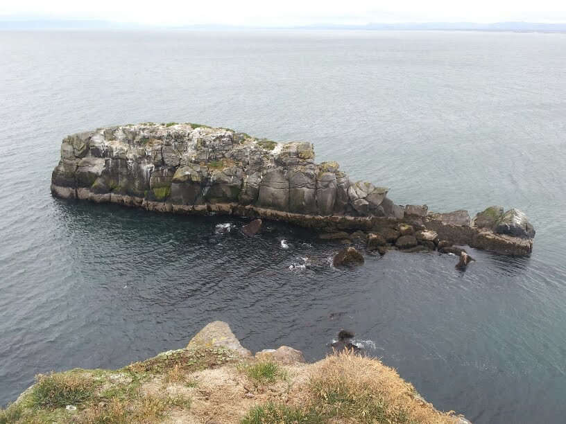
My walk was along the clifftops to the north in the general direction of Gardur. There was a path to begin with, but this soon petered out. This was obviously a place where seabirds lay their eggs because I was regularly being harried by Gulls and Terns. I was told that they can cause significant injury if they attack, so I put my rucksack on my head if they started swooping too close. I passed a small rocky island that looked like a whale and then reached the orange-painted Holmsbergsviti lighthouse I decided it was time to turn back when I reached a golf course that extended right to the cliff edge - I wondered how many balls end up in the sea.

By the time I got back to the B&B I had been out for four hours and walked about 10 miles. Renata's daughter drove me to the airport. On the way, she asked me what had been my favourite bit of Iceland. I struggled a bit to answer because there had been so many outstanding moments, but eventually concluded that it was the final day's walk on the Laugavegur trail from Alftavatn to Landmannalaugar.

I felt I had used my time well and gained a good appreciation of this wonderful country. However, I now needed a holiday before my September expedition to Corsica, so I was quite looking forward to relaxing at home for a bit.

Saturday 8 August 2015

NORTH ICELAND

BASALT COLUMNS AT HOFSOS
TURF ROOF AT SIGLUFJORDUR
SIGLUFJORDUR FROM OVERLOOKING HILL
THE RED TRAFFIC LIGHTS IN AKUREYRI SAY 'I LOVE YOU'
ROCK PILLAR AT MYVATN
VIEW FROM MYVATN NATUREBATH
VIEW OF MYVATN FROM TOP OF VINDBELGJARFJALL
GODAFOSS
I woke at the Broddanes hostel at 6.00am and proceeded to tuck into a breakfast of Chocolate Weetos (from the free cupboard) and banana (which I had brought), with Coffee Mate as a substitute for milk. Though still overcast, the weather had calmed and I watched the Arctic Terns wheeling and cavorting while I ate. I noticed how their fan-tails spread when flying slowly or hovering, but sleeked back when they were flying fast. I remembered that one had kept pace with me the other day as I crossed a bridge at 50mph.

By 7.30am I was off, out of the Westfjords and heading south to join Route 1. 

Just in case this isn't clear already, Route 1 is Iceland's main highway, and it goes all the way around the island in a big distorted circle. It's  bit like the M25 London Orbital, only bigger, and whereas the Orbital encloses an area with a huge population, much of the area enclosed by Route 1 is either volcanic wasteland, including lavafields and glaciers, or areas uninhabitable for much of the year because of the harsh climate.

Anyway, I turned left, meaning that I was now travelling clockwise around Route 1. What immediately struck me was the lack of cars. Here was I on the county's main highway during the rush hour, and most of the time it was empty. I wish the M25 was like this.

It was quite foggy, so there was little to see, but progress on Route 1 was much more rapid than driving around the Westfjords because the roads are straighter. After a couple of hours I turned right onto Route 76. This would take me to my hostel at Siglufjordur at the end of the Trollaskagi peninisula, otherwise known as the Troll peninsula. Along the way I wanted to visit Hofsos.

Hofsos is a pretty fishing village with a population of about 200. However, what particularly interested me was the coastal rock formations. When thick layers of basalt lava cool rapidly, the resulting contraction can cause vertical fractures to appear in such a way that polygonal columns are formed. I just had to see this and I was not disappointed.

Besides, this saves me a trip to see the Giant's Causeway in Northern Ireland, which is the result of the very same process.

I reached the Siglufjordur hostel at about 3.00pm, checked in, then went to explore. The town developed and reached its peak in the 1940's and 50's because of herring fishing. The herring are gone now and the population has fallen to around 1,200, but fishing remains a principal component of its economy. The town is a clean and attractive place, and I liked the cottage with a turf roof. I walked up the hill on the western side to get an aerial view and take some pictures of the boats and colourful buildings.

I shared my dorm with Chloe and Valerie, two young girls from Canada, who were spending nearly a month exploring Iceland. Their next stop was Akureyri, Iceland's second city, so when they heard that I was passing that way in the morning, they asked if I would give them a lift. Being a gentleman, I duly obliged. After dropping them close to the centre, I parked the car and had a quick look around. It was a nice enough place, though not worth a special trip unless intending to use it as a base for a walking holiday. One interesting thing is that the red light on all the local traffic lights is in the shape of a heart. Apparently, this was done to cheer people up and get them thinking positively after the 2008 financial crash. Also, the Visitor Centre did have some useful information about Myvatn, my next destination.

Myvatn is a lake that was formed a mere 2,300 years ago by huge volcanic activity. There are all manner of volcanic phenomena to be seen at the lake and in the surrounding area; craters, lavafields, signs of massive ground upheaval, pseudocraters caused by steam explosions, rock pillars and hot springs. The place is a vulcanologist's dream and a fascinating place for anyone to explore. 

I had two objectives for the day:

The first was to visit the Myvatn Naturebath, where I was able to enjoy a relaxing dip in geothermal water, rich in minerals, from 2.5 kilometres underground, whilst enjoying the view of the lake and surrounding mountains. It was most relaxing, and good for the skin I am told.

My second was to climb a volcano, and I chose the 529m Vindbelgjarfjall. I got to the top from the road in just 40 minutes, catching up with a few other people as I climbed. Once there, however, I found myself surrounded by swarms of midges, so I quickly took some pictures and made my way down even more rapidly. It was only later that I found out that Myvatn means Midge Lake!

Myvatn is as far east as I had intended to go in Iceland. Many visitors to the country drive around the whole of Route 1 in a week, but then miss out on the Westfjords which, in my view, is one of the best bits. I was happy that my itinerary had given me a really good appreciation of the many different flavours of Iceland.

It was now about 4.00pm and I had four hours of driving ahead of me to get to my next hostel at Saeberg, by Hrutafjordur. However, it would be easy-going on Route 1, anticlockwise this time, and at least I don't have to worry about it getting dark. Just as well as I had noticed that the car had lost a headlamp bulb. Since it is a legal requirement to drive with headlamps on, I used the front spotlamps as a substitute.

I did stop briefly at Godafoss (God's waterfall) along the way. It created a lovely display, but Iceland has so many lovely waterfalls that it is easy to get blase about them.

Reaching my hostel a Saeberg marked the end of my brief trip to North Iceland. Tomorrow I will be back at the Bus Hostel in Reykjavik.

Thursday 6 August 2015

MORE WESTFJORDS

BILDUDALUR HARBOUR
DYNJANDI WATERFALL
NO BARRIERS ON THE MOUNTAINSIDE ROADS
KORPUDALUR FARM
DULL ISAFJORDUR TOWN CENTRE
SAUTEED PUFFIN, ANYONE
RUGGED COAST NEAR HOLMAVIK
BRODDANES HOSTEL
It's Tuesday and today's drive is not very far, so I thought I would explore Bildudular further. I walked around the small harbour and up the overlooking hill where barriers had been built to deflect avalanches away from the town. By the time I departed to continue my drive around the fjords it was nearly 11.30am.

After an hour and a half I reached a suitable spot for my picnic lunch by the magnificent Dynjandi waterfall. The water plunges 100m in several fan-shaped cascades. There are five more waterfalls below it, but Dynjandi is certainly the most impressive.

I had booked a bed for the night at a place called Korpudalur so I continued my way along Route 60 at an easy-going pace, taking in the scenery. When I reached the top of the mountain pass at Hrafnseyrarheidi I stopped with the intention of walking around. However, the wind was so strong that I had to use two hands to restrain the car door. It was also so bitterly cold that I quickly retreated back into the car and drove on.

It turned out that my hostel at Korpudalur was actually an old farm. Apparently it was already full when my booking was made, but the kind owners had found extra space by putting me in the barn. It was obvious that turning the barn into guest accommodation was 'work in progress', and I had to walk to the main house nearby to shower and cook. It was comfortable enough, though, and they didn't charge me much.

The following morning's weather was foggy and overcast, and it had clearly rained overnight. I drove to Isafjordur, a 'cosmopolitan hub' according to Lonely Planet, and the largest town in the Westfjords with a population of, wait for it, 2,525 people (plus and minus a few births and funerals). The economy has traditionaly been based on fishing but I suspect the tourism also makes a large contribution these days.

Sadly, my own impression of Isafjordur was rather less upbeat than the publicity would have me be. I found it a rather grey tatty town without much to commend it. Even the tourist office said little about the town itself, but had lots about attractions that might be found somewhere else. The last straw was when I looked at the restaurant menu at the Hotel Isafjordur and saw that it included sauteed puffin! How could they? I drove off on disgust.

My coastal drive along Route 61 was a lot longer than it looked because of the huge distances involved in going around the fjords. I broke the journey up a bit by stopping at intervals, firstly near Hvitanes to watch seals lazing on the rocks and next at Reykanes to bathe in the hot-pot, as they call their naturally heated pools. The rain was almost continuous, but it had the decency to stop whenever I wanted to get out of the car.

Leaving the fjords and crossing the mountains to Holmavik was quite an experience. The high plateau was wet, cold, windy, foggy and spooky. With a name like Steingrimsfjardarheidi I'm not surprised. Apart from the spooky bit, it didn't get much better when I got back down to the coast. Leaving Route 61 to continue along Route 68, I could see how hard life must be for the coastal farming communities here.

Finally I reached my hostel at a place called Broddanes, a stones throw from the waterside. They didn't seem to have received my booking, but let me stay anyway. Thank goodness. It was bleak outside and I didn't fancy either the car or the tent.

This more-or-less completes my tour of the Westfjords. Tomorrow I will be in North Iceland.

Monday 3 August 2015

SNAEFELLSNES & WESTFJORDS

MY CHARIOT
TECHNICOLOR CROSSING AT BORGARNES
THE SHAEFELLJOKULL VOLCANO
DERELICT SKI LIFT
MEMORIAL TO GUDRIDUR THORBJARNARDOTTIR
BASALT COLUMNS ON COAST
STEEP CLIFFS AND HIGH PLATEAUS ON WAY TO LATRABJARG
PUFFIN AT LATRABJARG CLIFFS
The car had left-hand drive, and I hadn't driven one of those for a good while, so I practiced on the back roads near the hostel before venturing onto the main roads. The maximum speed limit on tarmac roads in Iceland is 90kph (56mph), which quite suited me.

From Reykjavik I initially drove north along Route 1, reaching the 3.6 mile long Hvalfjordur tunnel which costs 1,000 ISK (about £5) to pass through. The traffic was busy at first, but gradually thinned out as I got further away from the city. I randomly stopped at places that I thought might be of interest such as Akranes and Borgarnes. At the latter I came across a technicolour zebra crossing - so much more cheerful than boring monochrome ones seen elsewhere. I think that Icelanders love colour to lift their spirits in the long grey winters.

Leaving Route 1 at Borganes, my target for the day was to get somewhere near the end of the Snaefellsnes peninsula. By now my journey had become a pleasant evening drive on largely empty roads. I ended up at Arnarstapi, managing to find a quiet spot for the night up a gravel side track. I folded the rear seats down, but sleeping in the back of the car wasn't that comfortable because it wasn't flat. Still, I managed.

In the morning I could begin to appreciate the landscape much more as the sun rose higher in the sky. I had parked just south of the Snaefelljokull volcano and resolved to take a morning walk up to the edge of the glacier that dominates the view of the peninsula from all directions.

French novelist Jules Verne made Snaefellsjokull world famous in his novel 'Journey to the Centre of the Earth' as it was by going down a crater on Snaefellsjokull that his three adventurers reached the centre of the earth before eventually being carried out to Stromboli, Italy, in an eruption.

After about 2 hours of walking I reached the ruins of an old ski lift - perhaps a casualty of global warming - and could see over to the north side of the peninsula.

Returning to the car, my next stop was Hellnar, where they had an informative visitor centre with old photographs showing what life was like for the fishing communities on the peninsula. I also made a short stop at a sculpture commemorating Gudridur Thorbjarnardottir, the first woman to give birth to a white baby in North America.

I enjoyed my picnic lunch at Londranger (no, not Lone Ranger), where basalt columns and magnificent rock columns were visible from the cliffs and then, continuing my drive around the head of the peninsula, stopped briefly to climb the 109m, 3-4,000 year old Saxholl crater which is close to the road.

Time was moving on. I picked up some food at Stykkisholmur after which the road surface changed from tarmac to gravel as I left the peninsula. That slowed me down a bit until I reached Route 60 and turned north, heading for the Westfjords.

I passed by a filling station at Budardalur; ten minutes later it occured to me that this might be the last opportunity to fill up for a while, so I turned back. It was a good call because I didn't come across any more filling stations that evening.

Having crossed the Gilsjordur bridge I was now in the Westfjords, but since the sun would be directly in my eyes for the rest of the evening, I decided to stop near Bjarkalunder for the night and continue in the morning with the sun behind me.

At 8.00am I was on my way again. Yesterday's scenery had comprised lavafields around Snaefellsjokull which, as I continued to the Westfjords, became farmland - where it wasn't too mountainous, that is. Now the scenery reminded me of Scotland, with twisty roads weaving between steep mountains. Then there were the fjords, of course, many of them so long that it was hard to tell if they were connected to the sea or not.

The road was narrow and, at times, precipitous, and the surface ranged from tarmac to gravel. It certainly demanded concentration. I stopped for coffee at an hotel at Floklunder, then left Route 60 for Route 62, which enabled me to stay close to the coast and remain on tarmac a little longer. However, I was aiming for Latrabjarg, the westernmost point of Iceland and the place where puffins and other birds can be seen in great numbers. This can only be reached by enduring 30 miles of gravel road. I just hoped that I didn't get a puncture.

I noted that the mountain terrain had changed again. Now it was high plateaus edged with steep cliffs which fell sharply down to the sea. The coast roads got even more exciting since there was no barrier to stop cars driving right off the edge. I kept both hands firmly on the wheel at all times, especially when vehicles coming from the other direction passed me.

Along the way, at Hnjotor, I was surprised to see a dismantled US Navy Douglas C117 aircraft alongside the road. This type was apparently used to assist with emergency evacuation of Vestmannaeyjar (Westman Islands) during the volcanic eruptions in 1973. This particular aircraft was presumably bought by an Icelander when it was retired from service in 1977 and has ended up in this 'scrap' museum.

I parked the car at Brunnar, an old fishing station which went into disuse about 1880, and walked the remaining mile or so to Latrabjarg. Just as the Visitors' Guides had promised, the nearby cliffs were covered in birds, but it was the puffins I had come to see. I hadn't realised that they lived in holes in the cliff, effectively making them cave dwellers. They were incredibly tame and, by laying down with a camera close to the cliff edge, they would come almost right up to me.

Satisfied that I'd had my puffin 'fix', I ate my picnic lunch, walked back to the car and prepared for another 30 miles of gravel road to get back to Route 62, then another 25 miles of tarmac road to reach Bildudalur where I had booked a hostel. Still, it was sunny and warm, and I was in no hurry.

I arrived at Bildudalur around 6.00pm, found the hostel, and checked into my dorm for six (which I understood would be full tonight). It was a really nice place, spotlessly clean, right on the harbourside and surrounded by mountains.

And I heard that the cafe around the corner served beer........

Saturday 1 August 2015

RETURN TO REYKJAVIK

DESOLATE LAVAFIELD FROM THE BUS
A WELCOME BEER AT THE BUS HOSTEL
REYKJAVIK CITY CENTRE
MOI ON AN ICELANDIC HORSE
THE HARPA CENTRE
AMAZING VIEW INSIDE THE HARPA CENTRE
'HOW TO BECOME ICELANDIC IN 60 MINUTES'
NAUTHOLSVIK THERMAL BEACH
I was a little sad to leave beautiful Landmannalaugar, but being able to get back to Reykjavik a little earlier than expected would enable me to have a better look at the city.

The bus journey back was a treat in itself, though. The roads were little more than dirt tracks, and we had to drive through several fjords, which is something buses don't have to do in England. The Icelandic buses have large wheels and a high chassis, so are obviously made for this. That didn't stop them clattering noisily nor vibrating so much that it was impossible to rest my elbow on the window sill without it being thrown off.

The scenery that we passed was almost alien - huge flood plains followed by huge lava fields. The latter great grey expanses of solidified lava and ash were surreal - almost lunar. The newer lava fields were quite barren, whereas the older fields showed signs of life, with moss, grass and the occasional flower starting to colonise the wasteland. It was like watching creation in the making. Then it started to rain heavily; yet another ingredient of life. It seemed that the timing of my departure from Landmannalaugar had been perfect, although mountain weather is so localised that it might not actually be raining there.

Finally arriving back in Reykjavik, I quick-stepped my way to the Bus Hostel to be told that they could provide me with a bed for the two additional nights. Whoopee. After spending four nights on a half inch thick foam sleeping pad I really appreciated the comfort of a soft mattress.

A beer in the evening rounded the day off nicely.

Thursday morning involved doing the laundry and making some decisions about what to do with my extra city time. I then headed downtown to make some bookings for the following day (you will have to be  patient to find out what these are). I then visited Volcano House, which was very informative about the rocks and ash I had come across on my walk, and also the Saga Museum about the colonisation of Iceland by the Celts and the Vikings from the 9th century onwards.

Walking back along the main street, which incidentally is called Laugavegur, the same name as the trail, I was once again impressed by how a city with so many of its buildings clad with corrogated steel sheets could look so attractive. I think that the bright colours used to paint them has a lot to do with it. Finally, on my way back to the hostel, a visit to the Bonus supermarket was required to replenish my food supplies. It had been an easy-going day.

I was up early Friday, and ready when the man from Eldhestar stables came to pick me up. Along with a few others, I was driven to a large horse farm in Vellir, just east of Selfoss. We were each supplied with a riding helmet and matched with an Icelandic Horse which matched our previous experience with horses. The Icelandic horse is the only breed to be found in Iceland and it is renowned for its hardiness, its docile manner and its comfortable gait.

We were led as a group on paths surrounding the farm and then up into the overlooking hills. Though there was no galloping across the plains or anything like that, it was a pleasant way to spend a sunny morning.

Back in Reykjavik I made some preparations for the ensuing week by visiting one of the local Hostelling International hostels to see if they could pre-book some accommodation for me as I drove around the Westfjords and the north of Iceland. A car would be brought to the Bus Hostel for me tomorrow afternoon.

I was partially successful, but might end up sleeping in the car or my tent on some nights. Anyway, I'm as ready to go as I can be.

For the evening I had booked to see a comedy show at the amazing Harpa-Reykjavik Concert Hall and Conference Centre. The show was entitled 'How to become Icelandic in 60 Minutes'. It was obviously aimed at tourists, but nevertheless amusing enough to keep me occupied for an hour.

However, the real star of the show was the Harpa Centre itself. What an amazing structure, with internal walls looking like blocks of volcanic rock and the outside clad in glass polyhedrons inspired by the crystallised basalt columns commonly found in Iceland.

The comedian joked that this, the most expensive building in Iceland, was being constructed at the time of the country's financial melt-down. He promised that Iceland would pay the rest of Europe back -sometime.

On Saturday morning I took advantage of the sunshine to clean and dry my tent properly. Then I took a walk to Nautholsvik Thermal Beach to the south of Reykjavik. The sea around Iceland is generally too cold for bathing but this artificial cove is heated by natural hot water. The yellow sand was imported from Morocco. If I'd had more time I would have taken a dip, but there will be other opportunities.

Back at the hostel, the hire car was delivered by Jenny from Blue Car Rentals at 3pm, precisely, as agreed. Time for the next part of my Icelandic adventure!